It seems that the Great Powers have finally caught up with me. I even heard an Indian on NPR talking about India landing on the same spot where the Russians crashed yesterday.
I wrote these two connected posts on 14 November 2009 and 29 December 2005, respectively.
Playing Lunar Catch Up
14 NOVEMBER 2009 · 5:36 PM
Or is that “catsup”?
NASA found significant and meaningful amounts of water on the moon in the “bombing” of the South Pole a couple months back.
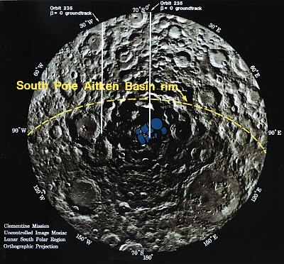
Navy: South Polar ice marked in blue
OK, the Huffington Post guy kind of got it:
Most Valuable Real Estate in the Solar System
Huffington Post (blog)
Today’s announcement by NASA of significant water on the south pole of the Moon is scientifically critical, economically astounding and extremely important …
Revealing water in significant quantities on the Moon could truly be a turning point in space exploration. Who will set up the first water mining plants? Given low-cost availability of water, hydrogen and oxygen, what type of off-Earth economies and exploration will this enable? The question is not too dissimilar to those questions asked when oil was discovered buried deep under the Earth or under the oceans. We eventually designed the technology to mine and extract this precious resource. It’s what we do as humans and entrepreneurs.
The south pole of the Moon has another very important attribute in addition to water, namely the existence of small mountain peaks that are constantly in sunlight, 28 days out of the Lunar cycle and referred to as the “peaks of eternal light.” These peaks which are in the plane of the ecliptic (the plane that the Earth rotates around the sun) will allow for constant illumination of solar panels and heating of the spacecraft. The reason this is important is because the temperature on the Moon plummets from +100 degrees Centigrade to -150 degrees Centigrade as the Moon rotates into and out of direct sunlight…
Groovy. Glad to see that SOMEBODY finally caught up with me. Bill Nye (the science guy, and not the founder of the Laramie Daily Boomerang and nationally known humorist of the XIXth Cent.) sure as hell didn’t on MSNBC’s The Rachel Maddow Show Friday.

not the science guy
Here’s what I wrote on this blog on December 29, 2005:
… The new space race is on. Just remember: a base at the south pole of the moon* will be the “Rock of Gibraltar” of the solar system for several centuries to come. Whoever gets a base there first will have a huge strategic advantage over the other nations of Sol-3.
(* The moon is a navel orange: the navel is always in darkness, with frozen water, seemingly, both making a permanent base of any sort a MUCH easier proposition. Trust me, metal fatigue issues given the moon’s temperature differential between “night” and “day” are an engineering nightmare. As regards the South Lunar Pole: this astonishing finding was made by the Navy’s Clementine mapping satellite in spring 1994, nearly 25 years after the moon landing. Think about it: the SINGLE most prominent feature on the moon wasn’t known for three decades after we started littering its surface with spacecraft. For more information, see: http://astrogeology.usgs.gov/Projects/Clementine/ and, you can find the Clementine image of the “navel” at the South Lunar Pole at: http://www.solarviews.com/browse/moon/clmsouth.jpg and, see its “mother’ page at http://www.solarviews.com/cap/moon/clmsouth.htm )
If we get there first, I’m sure we can give it a snazzy name, like, say, Reagan Base, or, maybe Space Base Eagle Freedom. I dunno.
Courage.
Posted by: harto / 12/29/2005 02:21:00 AM
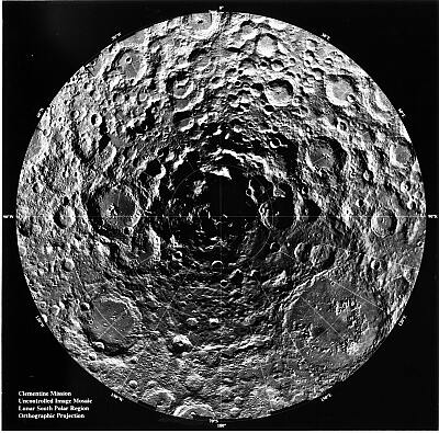
The moon is a navel orange (US Naval photo)
You might want to read the entire 2005 entry (scroll down past Mark Williams of KFBK, who I wrote about last week “MSNBC Gets Astroturfed Again « November 4, 2009” and on November 25, and 26, 2008, “Moving America Bass-ackwards” and “Thanking Sarah Palin“). The astronomical blog post is still out ahead of the conceptual thinking and policy, seemingly.
That’s what I get for having been trained by science fiction writers, I guess.
In the next week or so, I’ll tell you about even MORE thrilling things about the future! Meantime, I salute NASA and the Huffington Post for catching up.
Or is that “ketchup”?
Courage.
==================
Thursday, December 29, 2005
WHERE IS EUROPE?
or, HEED THE SIGNS AND GPS COORDINATES
Europe launched a satellite today. Big deal, right? Woop de do.
But this footnote in a preview news story (there was virtually no U.S. coverage of this event, prior to the launch) caught my eye:
“But Galileo is largely a political project, aimed at asserting Europe’s independence.” — Guardian (UK)
In this little-noticed news blurb lies a sad fact: after a century of fighting for a peaceful, unified Europe, and after the Cold War, a sea change is taking place. The teeter-totter is shifting balance, and we are being propelled upwards on our seat, at a rate fast enough that we might want to grab onto the handle, just in case we get thrown off.
Europe last night launched the first of their GPS satellites on a Soyuz rocket from Russia, , beginning work — signed onto by China and Russia — on a parallel system that the United States (“the Pentagon”) opposed as “wasteful.”
The rest of the world noticed that the US could turn off the GPS system at its own whim, in other words, and they don’t trust us that much anymore. Think about it: in a world where, increasingly, all land, sea and air navigation is done via GPS locators, the ability to shut off the signal, or scramble it so that only WE, the US can read it — well, that’s a scary thought if you’re the rest of the world, and think that the US is acting in entirely too flaky a manner to be fully entrusted with such a basic human need.
And so, with Russia and China and others, Europe is building their own GPS system, in parallel to the US Global Positioning System.
If you’re not up on how it works, The Smithsonian explains GPS this way:
Global Positioning System satellites transmit signals to equipment on the ground. GPS receivers passively receive satellite signals; they do not transmit. GPS receivers require an unobstructed view of the sky, so they are used only outdoors and they often do not perform well within forested areas or near tall buildings. GPS operations depend on a very accurate time reference, which is provided by atomic clocks at the U.S. Naval Observatory. Each GPS satellite has atomic clocks on board.
Each GPS satellite transmits data that indicates its location and the current time. All GPS satellites synchronize operations so that these repeating signals are transmitted at the same instant. The signals, moving at the speed of light, arrive at a GPS receiver at slightly different times because some satellites are farther away than others. The distance to the GPS satellites can be determined by estimating the amount of time it takes for their signals to reach the receiver. When the receiver estimates the distance to at least four GPS satellites, it can calculate its position in three dimensions.
There are at least 24 operational GPS satellites at all times. The satellites, operated by the U.S. Air Force, orbit with a period of 12 hours. Ground stations are used to precisely track each satellite’s orbit.
You might say that GPS is a system of lighthouses for anyone anywhere on the planet. But the US Air Force can turn off those lights at will, or, in a military engagement, potentially encrypt the GPS signals so that US forces know where they are, but everyone else in the world doesn’t.
So, the launch of the first NON-US GPS system by the rest of the world sets up a natural dynamic of Them versus Us, a polarization that is new to America.
Prior to World War I, we weren’t considered quite a “world power.” Sure, we’d just beat Spain, but it was thought that Spain was in pretty bad shape anyway.
And then, from our entry into World War I to the present day, we’ve been in Europe trying to stop these fantastic wars from erupting again and again, as they have for millennia.
Now, brilliant fools that we are, we are trying to show a region in which civilization was born millennia ago HOW to have a “real” government, because we’re spreading freedom.
Paranoia too.
Consider the COST of a parallel GPS system of 24 continuously maintained satellites (not to mention replacements when one goes bad). That’s a real sign that we’re spreading freedom, when so many would spend so much to make sure we couldn’t pull the rug out from under them.
Still, were we they, we’d do the same as them. And them did. And are doing, still.
The launch had been postponed from earlier in December. But it also signals the beginning of a real parallel space program from Europe.
For a long time, we’ve (with the Russians) been the gatekeepers of space. China has now sent two manned missions in the past year or so. Russia is selling space to zillionaires, and it’s interesting that Europe had a Soyuz launch the missile, rather than the EU’s French Arianne rocket, which they’ve been using for satellite payloads for a decade and more.
Perhaps it was to send a message. Perhaps it was just cheaper to hire the Russians. After all, the Russians have long been the champs at sheer lifting capacity. It was because of that extra lift they had that they went into space with vacuum tubes, and we were forced to transistors, then printed circuit boards, then to microchips. We couldn’t lift all those heavy vacuum tubes. They could.
And now they’re lifting Europe.
You are seeing the first glimpses of a fundamental realignment of world alliances. For fifty years, we had taken our alliance with Western Europe, NATO and the rest as a given.
But now a new center of gravity seems to be forming, and it is forming as Europe, China and Russia pull closer together in mutual interest, and as they draw away from us.
This is, frankly, something where the “UNDO” button won’t work. No Control-Z for this. In less than five years, George W. Bush has undone a century of American statesmanship, all the while, selling the debt to the Japanese, Chinese and Koreans, for whom our children will work, just to pay off the interest on the loans that George took out while he was defriending (sic) the world.
Somewhere up there, the second Sputnik is sending back its calibrating data, from the GIOVE-A satellite to mission control. Here is the story, in three news clips.
Daily News & Analysis, India
Galileo satellite launch delayed[Various] Agencies
Sunday, December 18, 2005 21:41 ISTPARIS: The launch of the first test satellite for the European Space Agency’s Galileo civil navigation system has been delayed by two days to December 28, the Roskosmos Russian space agency has said.
“Following a request from its sponsor (the ESA), the launch has been put back from December 26 to December 28,” said Roskosmos spokesman Vyacheslav Davidenko, quoted by the Itar-Tass news agency Saturday.
The GIOVE-A satellite had been due to blast off from Russia’s launch site at Baikonur, Kazakhstan, on December 26, to test technologies for the joint EU-ESA project to build the first civil satellite navigation system. The payload, to be launched by a Russian Soyuz rocket, will comprise a British-built 600-kg satellite that will be placed in orbit at 23,000 km.
But the ESA requested a delay until at least December 28 to correct an anomaly detected in the ground station network.
And ….
Europe’s space race with US begins
* GPS monopoly challenged by new satellite network
* China snubs America to be involved in projectIan Sample, science correspondent
Tuesday December 27, 2005At 3am tomorrow morning a Russian Soyuz rocket is set to streak into the skies over Baikonur Cosmodrome in Kazakhstan carrying a satellite that is purpose built to break one of the most ubiquitous monopolies on Earth.
If all goes according to plan, the rocket will soar to a height of 14,000 miles before releasing Giove-A, a wardrobe-sized box of electronics, into orbit. Once in position it will gently unfold its twin solar panels and begin to loop around the planet twice each day. In doing so, Europe’s most expensive space project, a rival to the US military-run global positioning system GPS, will have taken its first step.Giove-A is a test satellite that paves the way for a network of 30 more to be launched in 2006 and beyond. Together they will form Galileo, a £2.3bn global positioning system more reliable and accurate than GPS.
Galileo has been hailed in Europe as a means to make money. The highly accurate tracking system means road charging could be automated, air traffic monitored with unprecedented precision and goods tracked to people’s doors. With mobile phones due to include satellite-positioning receivers, emergency calls will be traced to within a metre. If industry embraces Galileo, it could drive a multibillion euro market, say experts.
But Galileo is largely a political project, aimed at asserting Europe’s independence. Although GPS is free and ubiquitous, it is optimised for America and the accuracy of the system can drift by more than 30ft. GPS is controlled by the US military which has the power to degrade or switch off the signal at will. Because Galileo will be a highly accurate civilian system run by a private consortium, supporters believe it will usher in a new range of safety-critical services, such as aircraft and emergency vehicle guidance systems.
Richard Peckham of EADS Astrium, a partner in the project, says that the Galileo network is being launched at a time of increasing dependence on satellite positioning systems. “Car satellite navigation systems seem to be this year’s top selling Christmas gadget,” he said. “It is becoming an intrinsic part of life.”
With Galileo, services that can position goods, people and vehicles to within three feet will be possible. While ramblers might make do with the free signal, emergency services could use an encrypted, more accurate signal to guide ambulances, fire engines or police cars to their locations with unprecedented precision.
Mike Dillon of ESYS, an electronics company involved in the project, says that ultimately Galileo could be used for automatic road charging, and improving safety on Europe’s roads by warning drivers of accident blackspots, junctions or curves in the roads. “Right now there are around 1.3bn accidents causing 40,000 fatalities each year,” he said. “That’s the equivalent of two jumbo jets full of passengers crashing every day.”
Although the European Space Agency is forbidden to take part in military projects, officials accept that once the signals are being broadcast the defence industry will undoubtedly take advantage of them, and develop devices that can operate with both GPS and Galileo.
According to plans, the Galileo satellites will be launched into orbit eight at a time. There they will form three rings around the Earth, with the full cluster of 30 due to be in place and working by 2010.
Giove-A, which was built in a record two years and three months by Surrey Satellites, is crucial to Galileo’s success. The satellite must be in orbit and transmitting useful positioning signals by July 2006 to meet a deadline set by the International Telecommunications Union (ITU). If the deadline passes and no Galileo signals are being broadcast from space, the European Space Agency will lose permission to use the frequencies and the project will be knocked back to the drawing board. With more than [Euros]130 million ([Pounds]89 million) invested, missing the deadline is an outcome the British government will not be keen to witness.
If the launch is successful, news that the satellite is working is likely to come from Chilbolton Observatory in Hampshire early on Wednesday morning. Scientists at the observatory will use a 25m receiving dish to hunt the heavens for signals from Giove-A as evidence that it reached the right orbit and powered up.
A failed launch will not necessarily mean the end of Galileo. A back-up satellite, which carries more new technology than Giove-A is on standby for launch to meet the ITU deadline.
Since its inception the Galileo project has been marred by disputes over financial contributions within the EU and rows with the US over the frequencies Galileo satellites would broadcast on. Military officials in America initially raised strong objections to Galileo because one of its signals was on a frequency close to the encrypted military signal used by US forces.
Their objections centred on the argument that if the US wanted to deny satellite positioning services to other countries they were in conflict with, they would have to jam Galileo’s signal, but in doing so risked jamming their own. Under intense pressure which nearly saw the Galileo project scrapped entirely, the EU backed down and moved the frequencies Galileo will broadcast on. The US also balked at China’s signing of a multimillion pound contract to be part of the Galileo project.
The launch tonight has special poignancy for engineers at the firm behind the satellite. It carries its own unusual cargo, a plaque inscribed with the name of Tom Fairbairn. The 25-year-old engineer worked on the probe at Surrey Satellites, a university spin-off company, until his life was cut short by the tsunami that struck the shores of the Indian Ocean on Boxing day last year.
Mr Fairbairn died with his parents when waves battered Khao Lak in Thailand where they were holidaying. “We hope the plaque will be a fitting tribute to Tom,” said Phil Davies of Surrey Satellites.
Footnote
GPS The US network is the most popular global satellite positioning system in the world. GPS satellites broadcast signals which, when picked up by a device on the ground, can show a user’s location to within 10 metres or so. The Russian Glonass system and Europe’s fledgling Galileo project work in the same way.
Test satellite Giove-A will not be part of the final 30 satellites that make up the Galileo network. It will try out new technology developed for the project and ensure that the European Space Agency claims the frequencies reserved for Galileo.
Encrypted GPS and Galileo have signals that anyone can pick up free of charge, but they also broadcast more reliable and accurate encrypted signals that have to be unscrambled. To use the US military GPS signal, US and allied forces must use special decryption software. The same signal is used by satellite-guided missiles.
European Space Agency Supported with money from member states, the ESA is embarking on ever more ambitious forays into space. The ESA is not allowed to fund military projects. To some, that position is compromised by the surety that Galileo will be exploited by the defence industry.
And, finally, from our own AP (I checked for US news items prior to the launch, but there were NONE listed on Google News).
SEATTLE POST-INTELLIGENCER
Europe launches first stage of its answer to GPS
Wednesday, December 28, 2005By ANGELA DOLAND
THE ASSOCIATED PRESSPARIS — The first satellite in the European Union’s Galileo navigation program was launched from Kazakhstan today, a major step forward for Europe’s answer to the U.S. Global Positioning System satellites.
The Galileo satellite, named “Giove A,” took off from the Baikonur Cosmodrome aboard a Soyuz rocket. Journalists monitored the liftoff through a linkup at the European Space Agency headquarters in Paris.
The $4.3 billion Galileo project will eventually use about 30 satellites and end Europe’s reliance on the GPS system, which is controlled by the U.S. military. Galileo is under civilian control.
Galileo will more than double GPS coverage, providing satellite navigation for motorists, sailors and mapmakers, among others. In particular, Galileo is expected to improve coverage in high-latitude areas such as northern Europe.
The first satellite will test atomic clocks and navigation signals and secure Galileo’s frequencies in space.
A second satellite named “Giove B” is scheduled to be placed in orbit in the spring. Two more satellites will then be launched in 2008 to complete the testing phase.
Last year, the EU and United States struck a deal to make Galileo compatible with the GPS system. The Pentagon had criticized Galileo as unnecessary and a potential security threat in wartime.
There. Now when your kids ask you: “When did you realize that the whole world was uniting AGAINST the USA?” you can say: “When the GIOVE-A was launched.”
I remember the FIRST Sputnik. I know it seems astonishing, but the adults were concerned about it, and told me about it, and even though I was two months shy of two years old, I REMEMBER it. It felt like the Cuban Missile Crisis did. It felt like 9-11. Not as intensely as either, but intense nonetheless.
In fact, the local astronomy club, the Eugene Astronomical Society was originally founded in 1957 as a Sputnik watching society. There was a new planet in the sky, moving very fast, and our ENEMIES, the Soviets, had put it there. Who KNEW what it would do?
It’s just like all over again deja vu.
But then, we have no one to blame but ourselves. And, given the infinite competitiveness of the naked killer monkeys of Terra (or Sol-3, as the inhabitants reckon it from their star), this sea change in world alliances was probably inevitable.
The new space race is on. Just remember: a base at the south pole of the moon* will be the “Rock of Gibraltar” of the solar system for several centuries to come. Whoever gets a base there first will have a huge strategic advantage over the other nations of Sol-3.
(* The moon is a navel orange: the navel is always in darkness, with frozen water, seemingly, both making a permanent base of any sort a MUCH easier proposition. Trust me, metal fatigue issues given the moon’s temperature differential between “night” and “day” are an engineering nightmare. As regards the South Lunar Pole: this astonishing finding was made by the Navy’s Clementine mapping satellite in spring 1994, nearly 25 years after the moon landing. Think about it: the SINGLE most prominent feature on the moon wasn’t known for three decades after we started littering its surface with spacecraft. For more information, see: http://astrogeology.usgs.gov/Projects/Clementine/ and, you can find the Clementine image of the “navel” at the South Lunar Pole at: http://www.solarviews.com/browse/moon/clmsouth.jpg and, see its “mother’ page at http://www.solarviews.com/cap/moon/clmsouth.htm )
If we get there first, I’m sure we can give it a snazzy name, like, say, Reagan Base, or, maybe Space Base Eagle Freedom. I dunno.
Courage.
Posted by: harto / 12/29/2005 02:21:00 AM
The end, 2023
Cross posted from his vorpal sword
A writer, published author, novelist, literary critic and political observer for a quarter of a quarter-century more than a quarter-century, Hart Williams has lived in the American West for his entire life. Having grown up in Wyoming, Kansas and New Mexico, a survivor of Texas and a veteran of Hollywood, Mr. Williams currently lives in Oregon, along with an astonishing amount of pollen. He has a lively blog, His Vorpal Sword (no spaces) dot com.


