


This stunning photo of the eye of Hurricane Dorian was taken on Sunday, September 1, from a U.S. Air Force hurricane hunter aircraft flying through the eye of Dorian.
The photo was tweeted by first lieutenant Garrett Black, an Air Force Hurricane Hunter, or “aerial reconnaissance weather officer.”
UPDATE II:
Puerto Rico is breathing a sigh of relief as Tropical Storm Dorian (now a Category 1 hurricane, and intensifying) grazed the island causing minor damage and “only” one confirmed casualty.
However, as Dorian has nothing but warm, open ocean between the Virgin Islands and the U.S. mainland, it is expected to grow into a major Category 3 hurricane possibly hitting the Florida coast over the Labor Day weekend.
UPDATE I:
Weather stories, especially ones about weather phenomena that could cause disastrous damage and even cost human lives, should not be political — and the original story on potential hurricane Dorian was not intended to be.
However, recent statements and planned actions by the president of the United States regrettably make it so now.
First, as tropical storm Dorian – forecast to potentially become a category 2 hurricane and possibly make landfall in Florida – approaches Puerto Rico, already devastated two years ago by hurricane Maria, Trump has slammed San Juan’s Mayor Carmen Yulín Cruz, as “incompetent” while “seeming to complain about how Puerto Rico has repeatedly been hit by major storms…”
Additionally, after having been “tepid” about past support for the by Maria devastated island, the Trump administration is reportedly planning to move $271 million, including, $155 million from FEMA’s Disaster Relief Fund, toward immigrant detentions.
Original Story:
Having been “on location” with a (not-so) lady named “Wilma” several years ago and planning a return engagement with Cancún in a few weeks, we are keeping a wary eye on the Atlantic Basin and the Gulf of Mexico.
Already the author’s namesake, tropical storm “Dorian,” is approaching the Eastern Caribbean and could reach hurricane status before crossing the Western Antilles.
Where it goes from there is still unclear, but according to one prediction, “Dorian is expected to make a bit more of a northward turn and head in the direction of Puerto Rico and Hispaniola around midweek,”
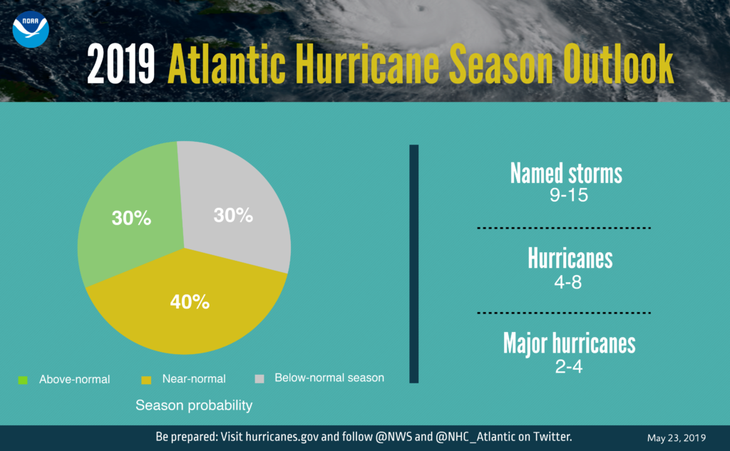
The National Weather Service and other government and private agencies are closely monitoring all tropical disturbances during what is fortunately expected to be, “a near-normal Atlantic hurricane season.”
By “near normal” the National Oceanic and Atmospheric Administration (NOAA) means “a 40% chance of a near-normal season, a 30% chance of an above-normal season and a 30% chance of a below-normal season.” The hurricane season extends from June 1 to November 30.
Nevertheless, NOAA predicts for 2019 “a likely range of 9 to 15 named storms (winds of 39 mph or higher), of which 4 to 8 could become hurricanes (winds of 74 mph or higher), including 2 to 4 major hurricanes (category 3, 4 or 5; with winds of 111 mph or higher).” (below) NOAA makes the prediction with a 70% confidence.
This season has been unusual because of several factors. Among them:
The formation of Subtropical Storm Andrea on May 20, marked the record fifth year in a row where a tropical or subtropical cyclone developed before the official start of the season.
It is also the second slowest-starting Atlantic hurricane season of the 21st century, as the third named storm formed on August 21.
NOAA attributes the 2019 “near-normal” season to two competing climate factors: The ongoing El Niño which suppresses the intensity of the hurricane season, countered by “the expected combination of warmer-than-average sea-surface temperatures in the tropical Atlantic Ocean and Caribbean Sea, and an enhanced west African monsoon, both of which favor increased hurricane activity.”
Whatever the reasons, those of us journeying to hurricane-prone locations and, more importantly, the people living in those areas hope that NOAA’s predictions are accurate this year.
And chances are that they will be, because the 2019 hurricane season marks the first time NOAA’s fleet of Earth-observing satellites includes three operational next-generation satellites that feed data to hurricane forecast models used to provide the public with the information needed to take action days in advance.
That is music to the ears of those who have faced the fury of a hurricane before. During our encounter with Wilma in 2005 we did not have such advance warning.
As I remembered Wilma a few years ago:
…early on a beautiful October morning…as my family, along with thousands of other tourists, were enjoying the sun on the beaches of Cancún, Wilma was merely a tropical storm wobbling aimlessly in the warm Atlantic waters about 250 miles South-East of Cancún. If and when Wilma developed into a Category 1 hurricane, there would be plenty of time to evaluate the situation and to safely leave Cancún.
The next day, a little over twenty-four hours later, the unbelievable had happened. Wilma had exploded overnight into a massive and vicious Category 5 hurricane…And, this monster was moving towards the Yucatán Peninsula. We attempted to arrange for flights out for my family…With flight cancellations, thousands of tourists clamoring for seats, and eventually the airport closing, this turned out to be a futile effort…
With NOAA’s forecast of “a likely range of 9 to 15 named storms,” the odds are that when our family visits Cancún again this fall, the naming sequence will not have reached the 19th name on the list, for it would be ironic, to say the least, to have to flee a storm named Tanya – our daughter’s name.